|
|
|
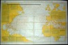
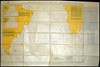
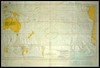
WWII US Navy Hydrographic Office Oil Cloth Life Raft Pilot Charts
(Click photo for larger picture)
|
|
|
|
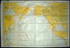
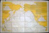
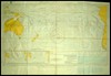
WWII US Navy Hydrographic Office Oil Cloth Life Raft Pilot Charts
(Click photo for larger picture)
|
| Side 1 | Side 2 | Size | # Printed | ||||
| 1400-w |
 |
North Atlantic Ocean (Winter) | 1400-w |
 |
North Atlantic Ocean (Summer) | 37" x 25" | 289,000 |
| 1401-w |
 |
North Pacific Ocean (Winter) | 1401-w |
 |
North Pacific Ocean (Summer) | 37" x 25" | 289,000 |
| 2600-w |
 |
South Atlantic Ocean (Summer) | 2600-w |
 |
South Atlantic Ocean (Winter) | 37" x 25" | 289,000 |
| 2601-w |
 |
South Pacific Ocean (Summer) | 2601-w |
 |
South Pacific Ocean (Winter) | 37" x 25" | 289,000 |
| 2603-W |
 |
Indian Ocean (Jan) | 2603-W |
 |
Indian Ocean (July) | 37" x 25" | 139,000 |
|
© Copyright 2008. All rights reserved.
|