|
|
|
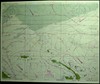
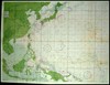
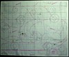
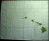
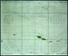
WWII Cloth Escape Charts US Naval Air Combat Intelligence -- Hydrographic Office
(Click photo for larger picture)
|
|
|
|
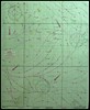
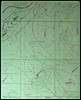
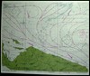
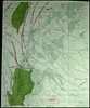
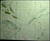
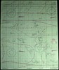
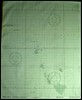
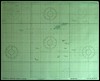
WWII Cloth Escape Charts US Naval Air Combat Intelligence -- Hydrographic Office
(Click photo for larger picture)
|
| Side 1 | Side 2 | Size | ||||
| OPNAV-16-V #S109 |
 |
The Use of Cloth Survival Charts in the Navigation of Rubber Rafts | (none) | 15 1/2" x 13" | ||
| S-7B-8-1 |
 |
Bonin Is. (Nov-Mar) |
S 7B-9-4 |
 |
Okinawa Shima & Parece Vela (Nov-Mar) |
13" x 15 1/2" |
| S8A-10-1 |
 |
North Central New Guinea (Nov-Mar) |
S-12-1-1 |
 |
Admiralty
Is. & N.W. Bismarck Arch. (Nov-Mar) |
15 1/2" x 13" |
| S-8B-3 |
 |
Luzon & Taiwan Is. (Nov-Mar) |
S-8B-4 |
 |
Mindanao, Philippine Is. (Nov-Mar) |
13" x 15 1/2" |
| S-12 |
 |
Western Pacific (Nov-Mar) |
S-12 |
 |
Western Pacific (May-Sep) |
36" x 27 1/2" |
| S12-1 & 25 |
 |
Bismarck Arch. & N.W. Solomon
Is. (Nov-Mar) |
S12-23 & 25 |
 |
E. Solomon Is. and Santa Cruz
Is. (Nov-Mar) |
15 1/2" x 13" |
| S 12-2-20 |
 |
Palau Island Area and N.W. New
Guinea (May-Sep) |
S12-2-40 |
 |
Western Caroline Is.
(May-Sep) |
13" x 15 1/2" |
| S12-2-32 |
 |
Eastern Caroline Is. (May-Sep) |
S12-19 |
 |
Marshall Is.
(May-Sep) |
15 1/2" x 13" |
| S12-2-36 |
 |
Central Caroline Is. (Nov-Mar) |
S12-17 |
 |
Marianas Is. (Nov-Mar) |
15 1/2" x 13" |
| S12-9 & 26 |
 |
Fiji & Tonga Is. | S12-20 & 16 |
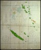 |
New Hebrides and Loyalty Is. (New Caledonia) |
15 1/2" x 13" |
| S12-8 |
 |
Ellice Is. | S12-11 |
 |
Gilbert Is. | 13" x 15 1/2" |
| S12-12 |
 |
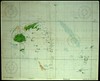
S.E. Hawaiian Is. | S12-14 |
 |
Upper Line Is. | 15 1/2" x 13" |
| S12-21 |
 |
Phoenix Is. (Howland, Baker, & Canton) | S12-29 & 22 |
 |
Union Group and Samoa Is. | 15 1/2" x 13" |
|
© Copyright 2008. All rights reserved.
|